Before the GPS Watch: How Runners Measured a Route
Before the GPS watch, runners measured routes with maps, landmarks and counted loops. Learn how these methods turned familiar streets into useful distance guides.
Before the GPS watch, runners measured routes by learning the ground: a bridge marked a turn, a map suggested a circuit, and a familiar loop supplied a repeatable distance. These methods did not put a live number on a wrist, but they gave runners practical ways to judge where they were and how far they had gone.
What could a landmark tell a runner?
A landmark was more useful than a vague sense of “far enough”. A railway footbridge, churchyard gate or distinctive bend could serve as a fixed point on an out-and-back route. Runners learnt the order of landmarks and used them as milestones, even when they did not know the exact distance between each one.
This was a form of local knowledge rather than precise measurement. A runner might know that the turn came after the allotments and before the canal towpath, then judge the return journey against the same sequence. The route became easier to remember because it was tied to visible features, not a list of street names.
Landmarks also helped with pace and effort. Reaching a familiar rise feeling unusually tired could suggest that the day’s effort was harder than usual, though it could not explain why. Wind, tired legs and a changed surface all affect how a route feels.
Choose landmarks that are fixed and easy to recognise from the direction you will approach them.
How did paper maps help estimate distance?
Road maps and walking maps let runners trace a route before setting out. A map’s scale offered a way to estimate the distance between points: follow the intended streets or paths, compare them with the scale, and add the sections together. This took care, because a route that looks straight on paper may bend around a park, cross a river at a particular bridge or follow a winding lane.
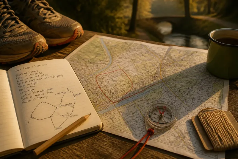
Some maps included a printed scale bar; others used a grid or marked distances between places. A ruler could help with a straight section, while a piece of thread laid along a curved route could then be compared with the scale bar. The result was an estimate, not a precise reading, but it was often sufficient to distinguish a short neighbourhood loop from a longer outing.
Map type mattered. A road map could show streets clearly but omit a footpath; a walking map might include paths and contours but simplify a road junction. Before relying on a line, check that the route is open to runners and that the map’s paths match what you can see on the ground.
For a first estimate, trace the route in short sections rather than trying to measure every curve at once.
Why did runners repeat loops?
A loop provided a natural unit of distance. Once a runner knew a park circuit or a set of local streets, repeating it made the outing easier to plan. The runner did not need to calculate the whole route afresh; the familiar circuit was the measure.
Loops were especially handy on tracks and in parks with clear boundaries. A marked athletics track offered a standard circuit, while an unmarked park loop could be estimated from a map or by comparing it with a known route. Those are different kinds of certainty: a marked circuit has an established length, while a neighbourhood loop depends on how accurately it was assessed.
Repetition also made distance visible in ordinary terms. “Three circuits of the park” was easy to remember and communicate, even if the runner had no exact figure to attach to it. The number of laps could guide the outing, while landmarks within each circuit helped prevent losing count.
Say a runner has a familiar path through a local park and wants a modest extension. They might add one short street loop that reconnects at the park gate, then use the gate and the pond as cues to keep the new route clear. The expected observable result is a route with an identifiable extra section, though its distance remains an estimate until measured against a map or known circuit.
What did a measured course offer?
Club runs, organised races and marked courses gave runners another reference point: a route whose distance had been set for a shared purpose. A course might be described by its start, turn points and finish, with signs or volunteers making the path easier to follow. For everyday runners, a known course could serve as a benchmark for planning other outings.
That reference was only useful if the route itself stayed the same. A temporary diversion, a closed path or a moved marker could change the course a runner actually covered. Familiarity helped spot such differences: a runner who knew where the route crossed a green or passed a footbridge could notice when the expected cue was missing.
Not every marked route had the same level of measurement behind it. A course could be laid out for a club session or community event without being measured to formal race standards. Treat its distance according to the information supplied by the organiser, rather than assuming every sign represents an exact figure.
How did runners keep a useful record?
Before digital logs, a small notebook could preserve routes and observations. A runner might write down the start point, turns, landmarks, surface and how the route felt. The purpose was not to create a perfect archive; it was to make a useful route possible to find again.
A simple route note might read: “Start at the library; follow the river path to the footbridge; return by the market road.” Add a sketch if two junctions look alike, or note which side of a park gate to use. Such details can matter more than a guessed distance when you are trying to repeat the route safely and consistently.
Keep estimates distinct from known measurements. A notebook can say “about the length of the club loop” or “map estimate” rather than turning an approximation into a precise-looking number. That small distinction helps later, especially when comparing routes from different sources.
Can old route methods still help today?
They remain useful whenever a digital signal is unavailable, unreliable or simply unwanted. A map and a sequence of landmarks can keep a runner oriented in a wooded park or along a winding riverside path. They can also make a familiar route easier to share with someone who does not use the same device or app.
These methods answer different questions from a GPS watch. A watch can display an ongoing estimate, while a paper map helps show where a route goes and how its sections connect. Landmarks tell you that you have reached a particular place; they do not, on their own, tell you the exact distance covered.
If you want to try a non-digital route estimate, start with a place you know and use a map with a visible scale. Trace the route in sections, note reliable landmarks, then compare your estimate with a known circuit if one is available. The main phrase, “before the GPS watch”, describes a practical skill as much as an earlier era: reading a route through its shape and landmarks.
Which method suits which route?
Are landmarks enough for a familiar loop?
They can be enough to follow a route and remember its order, especially when the landmarks are distinctive and close to the path. They are less useful for estimating exact distance unless the sections between them have been measured by another method.
Is a paper map better for a new route?
A map is useful for seeing how roads, paths and crossings connect before you leave. Check the map’s detail against the route on the ground, since printed paths may not show temporary closures or every minor turn.
Can a running track provide a dependable reference?
A clearly marked track gives a more standard circuit than an informal park loop. Follow the venue’s lane and direction markings, and do not assume that an unmarked loop nearby has the same length.
What should a route notebook include?
Record the start, turns, landmarks and any point where it is easy to take a wrong path. Mark a distance as an estimate unless it comes from a clearly identified measurement, so future you knows what the note can and cannot tell you.
For recreational runners, knowing a route has never depended on a single number. A paper map can explain its shape, a landmark can confirm your place, and a repeated loop can make distance familiar. Carry one clear route note when exploring somewhere new, and let the ground—not a confident-looking guess—tell you when a turn has changed.